
Thank you for supporting this site ❤️
Make a donation
Make a donation
Galesville topographic map
Click on the map to display elevation.
Thank you for supporting this site ❤️
Make a donation
Make a donation
About this map
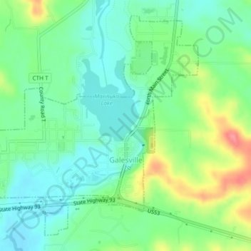
Name: Galesville topographic map, elevation, terrain.
Location: Galesville, Trempealeau County, Wisconsin, United States (44.07348 -91.37508 44.09715 -91.33818)
Average elevation: 231 m
Minimum elevation: 204 m
Maximum elevation: 286 m
Thank you for supporting this site ❤️
Make a donation
Make a donation
Other topographic maps
Click on a map to view its topography, its elevation and its terrain.
Perrot State Park
United States > Wisconsin > Trempealeau County > Town of Trempealeau
Average elevation: 223 m