
Thank you for supporting this site ❤️
Make a donation
Make a donation
Galilea topographic map
Click on the map to display elevation.
Thank you for supporting this site ❤️
Make a donation
Make a donation
Galilea
Galilea liegt etwa 23 km (Fahrtstrecke) ostsüdöstlich der Provinzhauptstadt Logroño in einer Höhe von ca. 560 m. Das Klima ist gemäßigt bis warm; Regen (ca. 683 mm/Jahr) fällt überwiegend im Winterhalbjahr.
Thank you for supporting this site ❤️
Make a donation
Make a donation
About this map
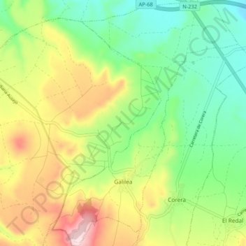
Name: Galilea topographic map, elevation, terrain.
Location: Galilea, La Rioja, Spanien (42.33182 -2.26040 42.39166 -2.19909)
Average elevation: 524 m
Minimum elevation: 389 m
Maximum elevation: 738 m
Thank you for supporting this site ❤️
Make a donation
Make a donation
Other topographic maps
Click on a map to view its topography, its elevation and its terrain.