
Margnat topographic map
Interactive map
Click on the map to display elevation.
About this map
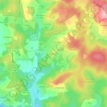
Name: Margnat topographic map, elevation, terrain.
Average elevation: 757 m
Minimum elevation: 684 m
Maximum elevation: 840 m
Other topographic maps
Click on a map to view its topography, its elevation and its terrain.
Combefort
France > Nouvelle-Aquitaine > Corrèze > Saint-Rémy
Combefort, Saint-Rémy, Ussel, Corrèze, Nouvelle-Aquitaine, France métropolitaine, 19290, France
Average elevation: 751 m
Cros Les Ganes
France > Nouvelle-Aquitaine > Corrèze > Saint-Rémy > Cros Les Ganes
Cros Les Ganes, Saint-Rémy, Ussel, Corrèze, Nouvelle-Aquitaine, France métropolitaine, 19290, France
Average elevation: 738 m
La Chassagne
France > Nouvelle-Aquitaine > Corrèze > Saint-Rémy
La Chassagne, Saint-Rémy, Ussel, Corrèze, Nouvelle-Aquitaine, France métropolitaine, 19290, France
Average elevation: 744 m