
Hancock topographic map
Interactive map
Click on the map to display elevation.
Hancock
According to the United States Census Bureau, the town has a total area of 31.2 square miles (80.9 km2), of which 30.0 square miles (77.6 km2) are land and 1.3 square miles (3.3 km2) are water, comprising 4.12% of the town. Hancock is drained by the Contoocook River, which flows northward along the eastern border of the town. Powder Mill Pond is in the east, and Nubanusit Lake is on the western border. Skatutakee Mountain, the highest point in Hancock, has an elevation of 2,002 feet (610 m) above sea level. Via the Contoocook River, Hancock lies fully within the Merrimack River watershed.
About this map
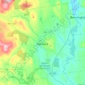
Name: Hancock topographic map, elevation, terrain.
Average elevation: 300 m
Minimum elevation: 179 m
Maximum elevation: 613 m