
Thank you for supporting this site ❤️
Make a donation
Make a donation
Palm Harbor topographic map
Click on the map to display elevation.
Thank you for supporting this site ❤️
Make a donation
Make a donation
About this map
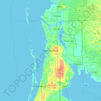
Name: Palm Harbor topographic map, elevation, terrain.
Location: Palm Harbor, Pinellas County, Florida, 34683, United States (28.03807 -82.80371 28.11807 -82.72371)
Average elevation: 9 m
Minimum elevation: -2 m
Maximum elevation: 32 m
Thank you for supporting this site ❤️
Make a donation
Make a donation
Other topographic maps
Click on a map to view its topography, its elevation and its terrain.
Largo
United States > Florida > Pinellas County
In 2010, Largo's total area was 18.6 square miles (48.1 km2), of which 17.6 square miles (45.6 km2) was land and 0.97 square miles (2.5 km2), or 5.22%, was water. As of 2004, there were 651 acres (2.6 km2) of park lands. The city's lowest elevation is sea level. At its highest, the city's elevation is about 69…
Average elevation: 9 m
Thank you for supporting this site ❤️
Make a donation
Make a donation
Thank you for supporting this site ❤️
Make a donation
Make a donation