
Thümmlitzwalde topographic map
Interactive map
Click on the map to display elevation.
About this map
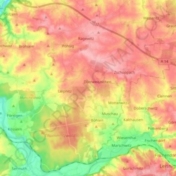
Name: Thümmlitzwalde topographic map, elevation, terrain.
Location: Thümmlitzwalde, Grimma, Leipzig, Sachsen, Deutschland (51.15649 12.76639 51.25305 12.92841)
Average elevation: 188 m
Minimum elevation: 121 m
Maximum elevation: 236 m
Other topographic maps
Click on a map to view its topography, its elevation and its terrain.
Mutzschen
Deutschland > Sachsen > Grimma
Mutzschen, Grimma, Leipzig, Sachsen, Deutschland
Average elevation: 189 m
Großbothen
Deutschland > Sachsen > Grimma
Großbothen, Grimma, Leipzig, Sachsen, Deutschland
Average elevation: 168 m