
Villard de Laye topographic map
Interactive map
Click on the map to display elevation.
About this map
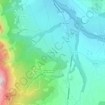
Name: Villard de Laye topographic map, elevation, terrain.
Average elevation: 1,225 m
Minimum elevation: 966 m
Maximum elevation: 2,116 m
Other topographic maps
Click on a map to view its topography, its elevation and its terrain.
Brutinel
France > Provence-Alpes-Côte d'Azur > Hautes-Alpes > Laye
Brutinel, Laye, Gap, Hautes-Alpes, Provence-Alpes-Côte d'Azur, France métropolitaine, 05500, France
Average elevation: 1,103 m
Canard
France > Provence-Alpes-Côte d'Azur > Hautes-Alpes > Laye > Canard
Canard, Laye, Gap, Hautes-Alpes, Provence-Alpes-Côte d'Azur, France métropolitaine, 05500, France
Average elevation: 1,303 m