
Allendorf topographic map
Interactive map
Click on the map to display elevation.
About this map
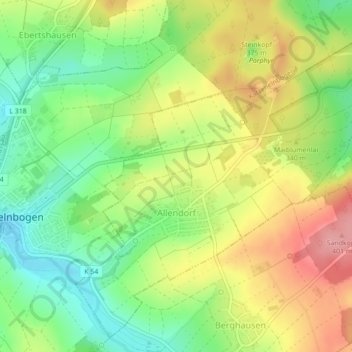
Name: Allendorf topographic map, elevation, terrain.
Average elevation: 334 m
Minimum elevation: 283 m
Maximum elevation: 394 m
Other topographic maps
Click on a map to view its topography, its elevation and its terrain.
Niedertiefenbach
Deutschland > Rheinland-Pfalz > Rhein-Lahn-Kreis
Niedertiefenbach, Aar-Einrich, Rhein-Lahn-Kreis, Rheinland-Pfalz, Deutschland
Average elevation: 319 m
Lahnstein
Deutschland > Rheinland-Pfalz > Rhein-Lahn-Kreis
Lahnstein, Rhein-Lahn-Kreis, Rheinland-Pfalz, 56112, Deutschland
Average elevation: 200 m
Bad Ems
Deutschland > Rheinland-Pfalz > Rhein-Lahn-Kreis
Bad Ems, Bad Ems-Nassau, Rhein-Lahn-Kreis, Rheinland-Pfalz, 56130, Deutschland
Average elevation: 245 m
Birlenbach
Deutschland > Rheinland-Pfalz > Rhein-Lahn-Kreis > Birlenbach
Birlenbach, Diez, Rhein-Lahn-Kreis, Rheinland-Pfalz, 65626, Deutschland
Average elevation: 197 m