Brattleboro topographic map
Interactive map
Click on the map to display elevation.
About this map
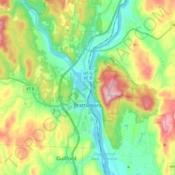
Name: Brattleboro topographic map, elevation, terrain.
Location: Brattleboro, Windham County, Vermont, 05301, United States (42.82400 -72.68063 42.89966 -72.53225)
Average elevation: 184 m
Minimum elevation: 60 m
Maximum elevation: 412 m
The town's densely populated center is located near Vermont's lowest elevation point in the Connecticut river valley. Because of the surrounding steep hills there is very little flat land, and many of its buildings and houses are situated on steep hillsides, necessarily closely bunched together. This concentrated topography and population density have helped to create a semi-urban, cosmopolitan atmosphere in the downtown.
Other topographic maps
Click on a map to view its topography, its elevation and its terrain.
West Brattleboro
United States > Vermont > Windham County > Brattleboro
West Brattleboro, Brattleboro, Windham County, Vermont, 05302, United States
Average elevation: 195 m
Somerset
United States > Vermont > Windham County
Somerset, Windham County, Vermont, United States
Average elevation: 698 m
Sherwood Forest
United States > Vermont > Windham County > Londonderry
Sherwood Forest, Londonderry, Windham County, Vermont, 05148, United States
Average elevation: 418 m
West Townshend
United States > Vermont > Windham County > Townshend
West Townshend, Townshend, Windham County, Vermont, United States
Average elevation: 295 m
Vernon
United States > Vermont > Windham County
Vernon, Windham County, Vermont, 05354, United States
Average elevation: 164 m
Halifax
United States > Vermont > Windham County
Halifax, Windham County, Vermont, 05358, United States
Average elevation: 443 m
Wardsboro
United States > Vermont > Windham County
Wardsboro, Windham County, Vermont, 05355, United States
Average elevation: 500 m
Williamsville
United States > Vermont > Windham County > Newfane
Williamsville, Newfane, Windham County, Vermont, 05362, United States
Average elevation: 270 m
Marlboro
United States > Vermont > Windham County
Marlboro, Windham County, Vermont, 05344, United States
Average elevation: 478 m
Stratton
United States > Vermont > Windham County
Stratton, Windham County, Vermont, 05360, United States
Average elevation: 663 m
Wilmington
United States > Vermont > Windham County > Wilmington > Wilmington
Wilmington, Windham County, Vermont, 05363, United States
Average elevation: 515 m
Putney
United States > Vermont > Windham County
Putney, Windham County, Vermont, 05346, United States
Average elevation: 225 m
Bellows Falls
United States > Vermont > Windham County > Rockingham > Bellows Falls
Bellows Falls, Rockingham, Windham County, Vermont, 05101, United States
Average elevation: 161 m
Athens
United States > Vermont > Windham County > Athens
Athens, Windham County, Vermont, United States
Average elevation: 343 m
Rockingham
United States > Vermont > Windham County > Rockingham
Rockingham, Windham County, Vermont, United States
Average elevation: 227 m
Londonderry
United States > Vermont > Windham County
Londonderry, Windham County, Vermont, United States
Average elevation: 455 m
Dover
United States > Vermont > Windham County
Dover, Windham County, Vermont, United States
Average elevation: 546 m
Townshend
United States > Vermont > Windham County
Townshend, Windham County, Vermont, United States
Average elevation: 370 m