
Thank you for supporting this site ❤️
Make a donation
Make a donation
Bear Mountain topographic map
Click on the map to display elevation.
Thank you for supporting this site ❤️
Make a donation
Make a donation
About this map
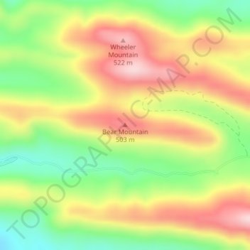
Name: Bear Mountain topographic map, elevation, terrain.
Location: Bear Mountain, Montgomery County, Arkansas, United States (34.48338 -93.62302 34.48348 -93.62292)
Average elevation: 403 m
Minimum elevation: 274 m
Maximum elevation: 532 m
Thank you for supporting this site ❤️
Make a donation
Make a donation
Other topographic maps
Click on a map to view its topography, its elevation and its terrain.