
Make a donation
Kiawah Island topographic map
Click on the map to display elevation.
Make a donation
Kiawah Island
Kiawah Island features a low-lying, sandy topography typical of barrier islands along the southeastern coast of the United States. The island's average elevation is about 10 feet above sea level, with some areas reaching slightly higher. Its terrain is characterized by broad, flat beaches that gently slope into the Atlantic Ocean, interspersed with lush maritime forests and salt marshes. These ecosystems create a rich biodiversity, supporting a variety of wildlife. The landscape includes both freshwater lagoons and saltwater estuaries, contributing to its unique ecological environment. Overall, Kiawah Island's topography offers a serene natural setting that enhances its appeal as a vacation destination.
Make a donation
About this map
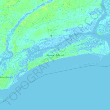
Name: Kiawah Island topographic map, elevation, terrain.
Average elevation: 2 m
Minimum elevation: -3 m
Maximum elevation: 13 m
Make a donation
Other topographic maps
Click on a map to view its topography, its elevation and its terrain.
Hobcaw Point
United States > South Carolina > Charleston County > Mount Pleasant
Average elevation: 4 m
Make a donation
Saint Andrews Heights
United States > South Carolina > Charleston County > Charleston
Average elevation: 5 m
Jamestown Estates
United States > South Carolina > Charleston County > James Island
Average elevation: 4 m
Brook Green Meadow
United States > South Carolina > Charleston County > Mount Pleasant
Average elevation: 4 m
Make a donation
Make a donation
Make a donation
Palmetto Fort
United States > South Carolina > Charleston County > Mount Pleasant
Average elevation: 4 m
Make a donation
Camp Saint Christopher
United States > South Carolina > Charleston County > Seabrook Island
Average elevation: 2 m
Remleys Point
United States > South Carolina > Charleston County > Mount Pleasant
Average elevation: 4 m
Make a donation
North Charleston Wannamaker County Park
United States > South Carolina > Charleston County > North Charleston
Average elevation: 8 m
Forest Park
United States > South Carolina > Charleston County > Charleston > Maryville
Average elevation: 5 m
Make a donation
Wando Estates
United States > South Carolina > Charleston County > Mount Pleasant
Average elevation: 5 m
Make a donation
Make a donation
Liberty Hill
United States > South Carolina > Charleston County > North Charleston
Average elevation: 7 m
Forest Trail
United States > South Carolina > Charleston County > Isle of Palms
Average elevation: 1 m
Make a donation
Saint Andrews Heights
United States > South Carolina > Charleston County > Charleston
Average elevation: 5 m
Ashley Junction
United States > South Carolina > Charleston County > North Charleston
Average elevation: 7 m
Make a donation
Camp Saint Christopher
United States > South Carolina > Charleston County > Seabrook Island
Average elevation: 2 m
Deerwood Heights
United States > South Carolina > Charleston County > North Charleston
Average elevation: 8 m
Northwood Estates
United States > South Carolina > Charleston County > North Charleston > Northwood Estates
Average elevation: 8 m
Make a donation
North Charleston
United States > South Carolina > Charleston County > North Charleston
Average elevation: 5 m
Country Club Estates
United States > South Carolina > Charleston County > Charleston
Average elevation: 3 m
Make a donation