
Thank you for supporting this site ❤️
Make a donation
Make a donation
Itu topographic map
Click on the map to display elevation.
Thank you for supporting this site ❤️
Make a donation
Make a donation
Itu
Itu is a historic municipality in the state of São Paulo in Brazil. It is part of the Metropolitan Region of Sorocaba. The population was 175,568 as of 2020, in an area of 640.72 km2. The elevation is 583 m. This place name comes from the Tupi language, meaning big waterfall. Two rivers flow through Itu: Tietê and Jundiaí. Itu has five hospitals, eleven bank agencies and one shopping center, the Plaza Shopping Itu.
Thank you for supporting this site ❤️
Make a donation
Make a donation
About this map
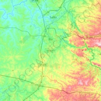
Name: Itu topographic map, elevation, terrain.
Average elevation: 630 m
Minimum elevation: 489 m
Maximum elevation: 942 m
Thank you for supporting this site ❤️
Make a donation
Make a donation
Other topographic maps
Click on a map to view its topography, its elevation and its terrain.