
Thank you for supporting this site ❤️
Make a donation
Make a donation
Halle topographic map
Click on the map to display elevation.
Thank you for supporting this site ❤️
Make a donation
Make a donation
About this map
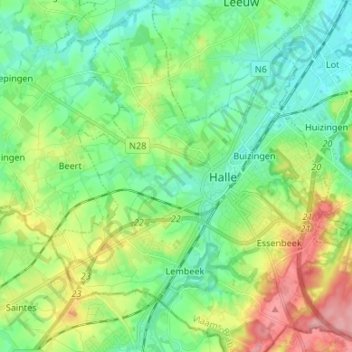
Name: Halle topographic map, elevation, terrain.
Location: Halle, Halle-Vilvoorde, Vlaams-Brabant, Vlaanderen, 1500, België (50.69408 4.18234 50.77855 4.31194)
Average elevation: 56 m
Minimum elevation: 22 m
Maximum elevation: 129 m
Thank you for supporting this site ❤️
Make a donation
Make a donation
Other topographic maps
Click on a map to view its topography, its elevation and its terrain.
Thank you for supporting this site ❤️
Make a donation
Make a donation
Thank you for supporting this site ❤️
Make a donation
Make a donation