
Le Sérac topographic map
Interactive map
Click on the map to display elevation.
About this map
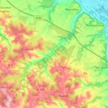
Name: Le Sérac topographic map, elevation, terrain.
Average elevation: 89 m
Minimum elevation: 18 m
Maximum elevation: 166 m
Other topographic maps
Click on a map to view its topography, its elevation and its terrain.
Constans
France > Nouvelle-Aquitaine > Lot-et-Garonne > Cocumont
Constans, Cocumont, Marmande, Lot-et-Garonne, Nouvelle-Aquitaine, France métropolitaine, 47250, France
Average elevation: 100 m