
Laborec topographic map
Interactive map
Click on the map to display elevation.
About this map
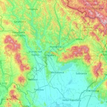
Name: Laborec topographic map, elevation, terrain.
Location: Laborec, Region of Košice, Eastern Slovakia, 072 37, Slovakia (48.50390 21.84034 49.26576 21.99176)
Average elevation: 320 m
Minimum elevation: 95 m
Maximum elevation: 1,174 m
Other topographic maps
Click on a map to view its topography, its elevation and its terrain.
Košice
Košice, Region of Košice, Eastern Slovakia, Slovakia
Average elevation: 314 m
Bara
Slovakia > Region of Košice > Bara
Bara, Region of Košice, Eastern Slovakia, 076 32, Slovakia
Average elevation: 168 m
District of Košice IV
Slovakia > Region of Košice > District of Košice IV
District of Košice IV, Košice, Region of Košice, Eastern Slovakia, Slovakia
Average elevation: 223 m
XII.
Slovakia > Region of Košice > District of Košice IV
XII., Košice - mestská časť Juh, District of Košice IV, Košice, Region of Košice, Eastern Slovakia, 04001, Slovakia
Average elevation: 218 m