
Make a donation
Upper Palatinate topographic map
Click on the map to display elevation.
Make a donation
Upper Palatinate
From the mid-13th century, much of the region was controlled by the Wittelsbach dynasty and until 1329 was ruled by the Wittelsbach Elector Palatine as part of the larger County Palatine of the Rhine (German: Pfalzgrafschaft bei Rhein). By the 1329 Treaty of Pavia, the Wittelsbach territories were divided between two branches of the dynasty. The territory around the Rhine river in the west became known as the Rhenish Palatinate (German: Rheinpfalz) or Lower Palatinate, and is today usually known simply as the Palatinate (German: Pfalz); it is from this territory that the modern German state of Rhineland-Palatinate derives its name. By contrast, the territory to the east centred on Amberg became known as the Upper Palatinate (German: Oberpfalz), upper and lower in this case referring to the elevation of the territories (compare Low and High German, Upper and Lower Lusatia, Upper and Lower Lorraine, Low Countries, Lower Saxony).
Make a donation
About this map
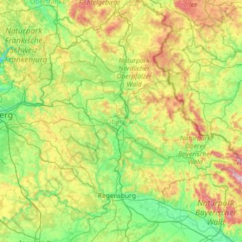
Name: Upper Palatinate topographic map, elevation, terrain.
Location: Upper Palatinate, Germany (48.76491 11.18592 50.06136 13.17090)
Average elevation: 488 m
Minimum elevation: 281 m
Maximum elevation: 1,317 m
Make a donation
Other topographic maps
Click on a map to view its topography, its elevation and its terrain.
Missen - Pšyne
Germany > Brandenburg > Oberspreewald-Lausitz - Górne Błota-Łužyca > Vetschau/Spreewald
Average elevation: 72 m
Make a donation
Wehr (Mosel)
Germany > Rhineland-Palatinate > Landkreis Trier-Saarburg > Palzem > Wehr (Mosel)
Average elevation: 201 m
Make a donation
Leichlingen
Germany > North Rhine-Westphalia > Rheinisch-Bergischer Kreis > Leichlingen > Leichlingen
Average elevation: 95 m