
Mantabuan Tabunan topographic map
Interactive map
Click on the map to display elevation.
About this map
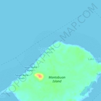
Name: Mantabuan Tabunan topographic map, elevation, terrain.
Location: Mantabuan Tabunan, Tawi-Tawi, Bangsamoro, Philippines (5.02144 120.18670 5.06144 120.22670)
Average elevation: 4 m
Minimum elevation: -2 m
Maximum elevation: 43 m
Other topographic maps
Click on a map to view its topography, its elevation and its terrain.
Tata Islands
Tata Islands, Tandubas, Tawi-Tawi, BARMM, 7502, Philippines
Average elevation: 3 m