
Thank you for supporting this site ❤️
Make a donation
Make a donation
Carroll topographic map
Click on the map to display elevation.
Thank you for supporting this site ❤️
Make a donation
Make a donation
About this map
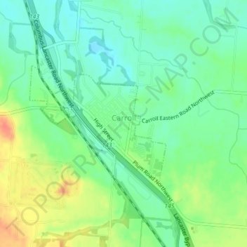
Name: Carroll topographic map, elevation, terrain.
Average elevation: 256 m
Minimum elevation: 238 m
Maximum elevation: 285 m
Thank you for supporting this site ❤️
Make a donation
Make a donation
Other topographic maps
Click on a map to view its topography, its elevation and its terrain.
Rush Creek Watershed Structure VI-D Dam
United States > Ohio > Fairfield County
Average elevation: 288 m
Thank you for supporting this site ❤️
Make a donation
Make a donation