
Macduff topographic map
Interactive map
Click on the map to display elevation.
About this map
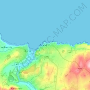
Name: Macduff topographic map, elevation, terrain.
Location: Macduff, Aberdeenshire, Scotland, AB44 1QN, United Kingdom (57.63021 -2.53444 57.71021 -2.45444)
Average elevation: 34 m
Minimum elevation: 0 m
Maximum elevation: 170 m
Other topographic maps
Click on a map to view its topography, its elevation and its terrain.
Crathie
United Kingdom > Scotland > Aberdeenshire > Crathie
Crathie, Aberdeenshire, Scotland, AB35 5UL, United Kingdom
Average elevation: 359 m