
Thank you for supporting this site ❤️
Make a donation
Make a donation
Culbertson topographic map
Click on the map to display elevation.
Thank you for supporting this site ❤️
Make a donation
Make a donation
About this map
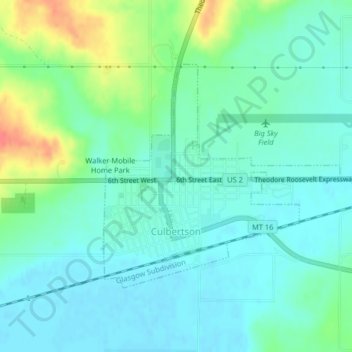
Name: Culbertson topographic map, elevation, terrain.
Location: Culbertson, Roosevelt County, Montana, United States (48.14054 -104.52490 48.15773 -104.49763)
Average elevation: 595 m
Minimum elevation: 580 m
Maximum elevation: 638 m
Thank you for supporting this site ❤️
Make a donation
Make a donation
Other topographic maps
Click on a map to view its topography, its elevation and its terrain.
Fort Peck Indian Reservation Historical Marker
United States > Montana > Roosevelt County > Poplar
Average elevation: 600 m