
Thank you for supporting this site ❤️
Make a donation
Make a donation
Port Henry topographic map
Click on the map to display elevation.
Thank you for supporting this site ❤️
Make a donation
Make a donation
About this map
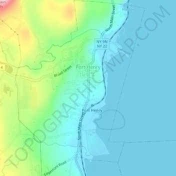
Name: Port Henry topographic map, elevation, terrain.
Location: Port Henry, Essex County, New York, 12974, United States (44.03326 -73.47128 44.05980 -73.44680)
Average elevation: 76 m
Minimum elevation: 27 m
Maximum elevation: 265 m
Thank you for supporting this site ❤️
Make a donation
Make a donation