
Thank you for supporting this site ❤️
Make a donation
Make a donation
La Plante topographic map
Click on the map to display elevation.
Thank you for supporting this site ❤️
Make a donation
Make a donation
About this map
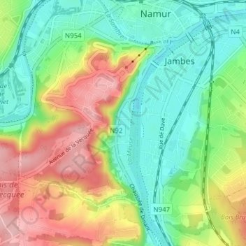
Name: La Plante topographic map, elevation, terrain.
Location: La Plante, Namen, Wallonië, 5000, België (50.42873 4.83791 50.46873 4.87791)
Average elevation: 129 m
Minimum elevation: 71 m
Maximum elevation: 220 m
Thank you for supporting this site ❤️
Make a donation
Make a donation