
Newbury topographic map
Interactive map
Click on the map to display elevation.
About this map
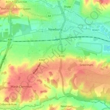
Name: Newbury topographic map, elevation, terrain.
Location: Newbury, West Berkshire, Angleterre, Royaume-Uni (51.36711 -1.35315 51.41456 -1.28819)
Average elevation: 97 m
Minimum elevation: 64 m
Maximum elevation: 135 m
Other topographic maps
Click on a map to view its topography, its elevation and its terrain.
Upper Lambourn
Royaume-Uni > Angleterre > West Berkshire
Upper Lambourn, Lambourn, West Berkshire, Angleterre, RG17 8RG, Royaume-Uni
Average elevation: 164 m
Sheffield Bottom
Royaume-Uni > Angleterre > West Berkshire > Sheffield Bottom
Sheffield Bottom, Burghfield, West Berkshire, South East England, Angleterre, Royaume-Uni
Average elevation: 57 m