
Thank you for supporting this site ❤️
Make a donation
Make a donation
Indian Lake topographic map
Click on the map to display elevation.
Thank you for supporting this site ❤️
Make a donation
Make a donation
Indian Lake
Indian Lake has the fourth-highest elevation of towns in Pennsylvania, at 2281 feet. This is the Lake water level, homes at Indian Lake range from 2300 to 2550 feet in base elevation.
Thank you for supporting this site ❤️
Make a donation
Make a donation
About this map
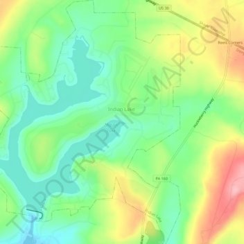
Name: Indian Lake topographic map, elevation, terrain.
Location: Indian Lake, Somerset County, Pennsylvania, United States (40.02331 -78.88721 40.06545 -78.83897)
Average elevation: 732 m
Minimum elevation: 679 m
Maximum elevation: 817 m
Thank you for supporting this site ❤️
Make a donation
Make a donation