
Frans-Guyana topographic map
Interactive map
Click on the map to display elevation.
About this map
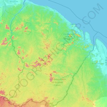
Name: Frans-Guyana topographic map, elevation, terrain.
Location: Frans-Guyana, Frankrijk (2.11094 -54.60269 5.74812 -51.63461)
Average elevation: 104 m
Minimum elevation: -2 m
Maximum elevation: 791 m
Other topographic maps
Click on a map to view its topography, its elevation and its terrain.
Remire-Montjoly
Remire-Montjoly, Cayenne, Frans-Guyana, 97354, Frankrijk
Average elevation: 18 m
Kourou
Frankrijk > Frans-Guyana > Kourou
Kourou, Cayenne, Frans-Guyana, 97310, Frankrijk
Average elevation: 35 m