
Cantois topographic map
Interactive map
Click on the map to display elevation.
About this map
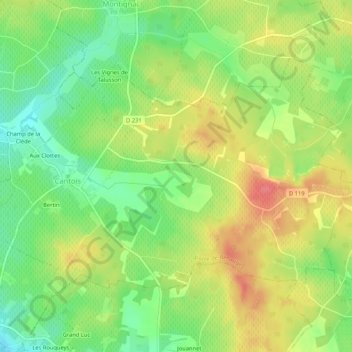
Name: Cantois topographic map, elevation, terrain.
Average elevation: 71 m
Minimum elevation: 39 m
Maximum elevation: 106 m
Other topographic maps
Click on a map to view its topography, its elevation and its terrain.
Arbis
France > Nouvelle-Aquitaine > Gironde > Porte-de-Benauge
Arbis, Porte-de-Benauge, Langon, Gironde, Nouvelle-Aquitaine, France métropolitaine, 33760, France
Average elevation: 59 m
Bertin
France > Nouvelle-Aquitaine > Gironde > Porte-de-Benauge
Bertin, Cantois, Porte-de-Benauge, Langon, Gironde, Nouvelle-Aquitaine, France métropolitaine, 33760, France
Average elevation: 61 m