
High Point State Park topographic map
Click on the map to display elevation.
High Point State Park
High Point State Park is a state park straddling the border of Wantage Township and Montague Township in Sussex County, within the Skylands Region of northwestern New Jersey, United States, near the border with New York State and Pennsylvania. The park covers 15,413 acres (62.37 km2). Part of the Kittatinny Mountains, the highest point in the state of New Jersey, the aptly named High Point, sits in the northern reaches of the park, at elevation 1,803 feet (550 m). Route 23 skirts the park and provides access for visitors from the New Jersey suburbs and from points in New York. The park is administered by the New Jersey Division of Parks and Forestry.
About this map
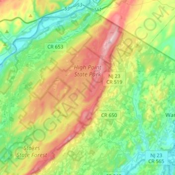
Name: High Point State Park topographic map, elevation, terrain.
Average elevation: 255 m
Minimum elevation: 110 m
Maximum elevation: 536 m
Other topographic maps
Click on a map to view its topography, its elevation and its terrain.
High Point
United States > New Jersey > Sussex County > Montague Township
High Point is a mountain peak within High Point State Park on the border of Wantage Township and Montague Township, Sussex County, New Jersey. Located in the portion of the state known as the Skylands, it is the highest elevation in the state, with a peak elevation of 1,803 feet (550 m). The closest city is…
Average elevation: 415 m
High Point
United States > New Jersey > Sussex County > Montague Township
High Point is a mountain peak within High Point State Park on the border of Wantage Township and Montague Township, Sussex County, New Jersey, United States. Located in the portion of the state known as the Skylands, it is the highest elevation in the state, with a peak elevation of 1,803 feet (550 m). The…
Average elevation: 415 m