Geolocate

Radon topographic map

Interactive map

Click on the map to display elevation.

About this map

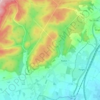
Name: Radon topographic map, elevation, terrain.

Location: Radon, Écouves, Alençon, Orne, Normandie, France métropolitaine, 61250, France (48.47855 0.05478 48.54163 0.11425)

Average elevation: 228 m

Minimum elevation: 146 m

Maximum elevation: 402 m

Other topographic maps

Click on a map to view its topography, its elevation and its terrain.

La Gare

France > Normandie > Orne > Écouves

La Gare, Vingt-Hanaps, Écouves, Alençon, Orne, Normandie, France métropolitaine, 61250, France

Average elevation: 185 m

L'Auberge

France > Normandie > Orne > Écouves

L'Auberge, Vingt-Hanaps, Écouves, Alençon, Orne, Normandie, France métropolitaine, 61250, France

Average elevation: 187 m

Les Rangées

France > Normandie > Orne > Écouves

Les Rangées, Vingt-Hanaps, Écouves, Alençon, Orne, Normandie, France métropolitaine, 61250, France

Average elevation: 186 m