
Thank you for supporting this site ❤️
Make a donation
Make a donation
Owls Head topographic map
Click on the map to display elevation.
Thank you for supporting this site ❤️
Make a donation
Make a donation
About this map
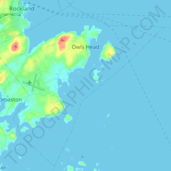
Name: Owls Head topographic map, elevation, terrain.
Location: Owls Head, Knox County, Maine, 04854, United States (44.01220 -69.13335 44.10654 -68.99374)
Average elevation: 4 m
Minimum elevation: -2 m
Maximum elevation: 57 m
Thank you for supporting this site ❤️
Make a donation
Make a donation
Other topographic maps
Click on a map to view its topography, its elevation and its terrain.