
Thank you for supporting this site ❤️
Make a donation
Make a donation
Güster topographic map
Click on the map to display elevation.
Thank you for supporting this site ❤️
Make a donation
Make a donation
About this map
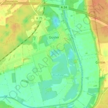
Name: Güster topographic map, elevation, terrain.
Average elevation: 22 m
Minimum elevation: 6 m
Maximum elevation: 43 m
Thank you for supporting this site ❤️
Make a donation
Make a donation
Other topographic maps
Click on a map to view its topography, its elevation and its terrain.
Rothenhusen
Deutschland > Schleswig-Holstein > Kreis Herzogtum Lauenburg > Groß Sarau
Average elevation: 20 m
Drüsen
Deutschland > Schleswig-Holstein > Kreis Herzogtum Lauenburg > Lehmrade
Average elevation: 40 m
Thank you for supporting this site ❤️
Make a donation
Make a donation
Dalbekschlucht
Deutschland > Schleswig-Holstein > Kreis Herzogtum Lauenburg > Börnsen
Average elevation: 40 m