
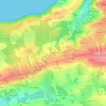
Kerliver topographic map
Interactive map
Click on the map to display elevation.
About this map
Name: Kerliver topographic map, elevation, terrain.
Average elevation: 52 m
Minimum elevation: 0 m
Maximum elevation: 106 m
Other topographic maps
Click on a map to view its topography, its elevation and its terrain.
Le Caon
France > Bretagne > Finistère > Telgruc-sur-Mer
Le Caon, Telgruc-sur-Mer, Châteaulin, Finistère, Bretagne, France métropolitaine, 29560, France
Average elevation: 45 m
Menez Kergreis
France > Bretagne > Finistère > Telgruc-sur-Mer
Menez Kergreis, Telgruc-sur-Mer, Châteaulin, Finistère, Bretagne, France métropolitaine, 29560, France
Average elevation: 49 m
Kergreis
France > Bretagne > Finistère > Telgruc-sur-Mer
Kergreis, Telgruc-sur-Mer, Châteaulin, Finistère, Bretagne, France métropolitaine, 29560, France
Average elevation: 53 m
Lotissement Kerspern
France > Bretagne > Finistère > Telgruc-sur-Mer > Lotissement Kerspern
Lotissement Kerspern, Telgruc-sur-Mer, Châteaulin, Finistère, Bretagne, France métropolitaine, 29560, France
Average elevation: 60 m
Le Ped
France > Bretagne > Finistère > Telgruc-sur-Mer
Le Ped, Telgruc-sur-Mer, Châteaulin, Finistère, Bretagne, France métropolitaine, 29560, France
Average elevation: 42 m