
Thank you for supporting this site ❤️
Make a donation
Make a donation
Löbelstein topographic map
Click on the map to display elevation.
Thank you for supporting this site ❤️
Make a donation
Make a donation
About this map
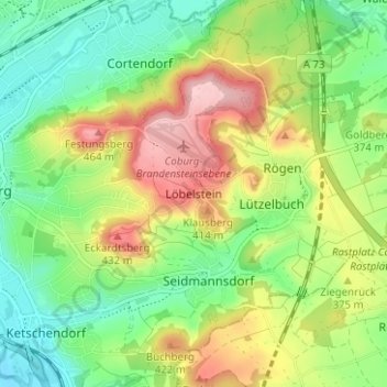
Name: Löbelstein topographic map, elevation, terrain.
Location: Löbelstein, Coburg, Bayern, 96487, Deutschland (50.23777 10.97778 50.27777 11.01778)
Average elevation: 354 m
Minimum elevation: 282 m
Maximum elevation: 462 m
Thank you for supporting this site ❤️
Make a donation
Make a donation
Other topographic maps
Click on a map to view its topography, its elevation and its terrain.
Veste Coburg
Deutschland > Bayern > Coburg > Löbelstein
Anstoß für die Baumaßnahmen war ein Geldgeschenk in Höhe von rund 20.000 Mark zur Wiederherstellung der Lutherkapelle der Gemeinden und des Landtages des Herzogtums Coburg zur Hochzeit von Herzog Carl Eduard und Viktoria Adelheid. Carl Eduard veranlasste daraufhin den Umbau und die Sanierung großer Teile…
Average elevation: 348 m