
Make a donation
Chollet topographic map
Click on the map to display elevation.
Make a donation
About this map
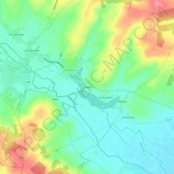
Name: Chollet topographic map, elevation, terrain.
Average elevation: 82 m
Minimum elevation: 52 m
Maximum elevation: 134 m
Make a donation
Other topographic maps
Click on a map to view its topography, its elevation and its terrain.
Aigre
France > Nouvelle-Aquitaine > Charente > Aigre
Le relief de la commune est celui d'un plateau assez vallonné descendant vers le centre où se trouve la vallée de l'Aume. Dans cette vallée se trouve la ville d'Aigre. Le point culminant est à une altitude de 151 m, situé au nord-est dans la forêt de Tusson. Le point le plus bas est à 60 m, situé le…
Average elevation: 90 m
Villejésus
France > Nouvelle-Aquitaine > Charente > Aigre
Le relief de la commune est celui d'un plateau assez vallonné descendant vers le sud-ouest où se trouve la vallée de l'Aume. Le point culminant est à une altitude de 151 m, situé au nord-est dans la forêt de Tusson. Le point le plus bas est à 60 m, situé le long d'un bras de l'Aume à l'extrémité…
Average elevation: 92 m