
Gurdaspur topographic map
Interactive map
Click on the map to display elevation.
Gurdaspur
All the Tehsils of the district namely Gurdaspur, Batala and Dera Baba Nanak are plain and similar to the rest of the Punjab plains in structure. The landscape of the district has varied topography comprising undulating plan, the flood plains of the Ravi and the Beas and the upland plain.
About this map
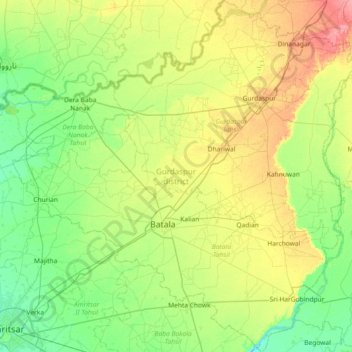
Name: Gurdaspur topographic map, elevation, terrain.
Location: Gurdaspur, Punjab, India (31.59355 74.88869 32.21387 75.60076)
Average elevation: 247 m
Minimum elevation: 225 m
Maximum elevation: 294 m
Other topographic maps
Click on a map to view its topography, its elevation and its terrain.
Nabha
India > Punjab > Nabha Tahsil
Nabha is located at 30°22′N 76°09′E / 30.37°N 76.15°E / 30.37; 76.15. It has an average elevation of 246 metres (807 feet).
Average elevation: 251 m
Amritsar
India > Punjab > Amritsar I Tahsil
Amritsar is located at 31°38′N 74°52′E / 31.63°N 74.87°E / 31.63; 74.87 with an average elevation of 234 metres (768 ft) in the Majha region of the state of Punjab in North India and lies about 15 miles (24 km) east of the border with Pakistan. Administrative towns includes Ajnala, Attari,…
Average elevation: 231 m
Budhlada
India > Punjab > Budhlada Tahsil
Budhlada is located at 29°56′N 75°34′E / 29.93°N 75.57°E / 29.93; 75.57 and has an average elevation of 211 metres (692 ft). The border of Haryana state is 25 kilometres (16 mi) away from the city.
Average elevation: 221 m
Amritsar
India > Punjab > Amritsar I Tahsil
Amritsar is located at 31°38′N 74°52′E / 31.63°N 74.87°E / 31.63; 74.87 with an average elevation of 234 metres (768 ft) in the Majha region of the state of Punjab in North India and lies about 15 miles (24 km) east of the border with Pakistan. Administrative towns includes Ajnala, Attari,…
Average elevation: 231 m
Amritsar
India > Punjab > Amritsar I Tahsil
Amritsar is located at 31°38′N 74°52′E / 31.63°N 74.87°E / 31.63; 74.87 with an average elevation of 234 metres (768 ft). Amritsar is located in the Majha region of the state of Punjab in North India lies about 15 miles (25 km) east of the border with Pakistan. Administrative towns includes…
Average elevation: 231 m
Faridkot
India > Punjab > Faridkot Tahsil
The average elevation is 196 metres (643 ft). The town is located on the Punjab Plains, which in a macro regional context forms a part of greater Satluj Ganga plain. It is a low-lying flat area. The surface of the district is depositional plain which was formed by alleviation by the rivers flowing in these…
Average elevation: 204 m
Nabha
India > Punjab > Nabha Tahsil
Nabha is located at 30°22′N 76°09′E / 30.37°N 76.15°E / 30.37; 76.15. It has an average elevation of 246 metres (807 feet).
Average elevation: 251 m
Patiala
India > Punjab > Patiala Tahsil
Patiala is located at 30°19′N 76°24′E / 30.32°N 76.40°E / 30.32; 76.40. It has an average elevation of 250 metres (820 feet). During the short existence of PEPSU, Patiala served as its capital city.
Average elevation: 255 m
Bathinda
India > Punjab > Bathinda Tahsil
Bathinda is in the northwestern region of India and is a part of the Indo-Gangetic alluvial plains. The exact cartographic co-ordinates of Bathinda are 30°12′N 74°57′E / 30.20°N 74.95°E / 30.20; 74.95. It has an average elevation of 201 metres (660 ft).
Average elevation: 208 m
Amloh
India > Punjab > Amloh Tahsil > Amloh
Amloh is located at. It has an average elevation of 259 metres (850 feet).
Average elevation: 261 m
Ludhiana
India > Punjab > Ludhiana (West) Tahsil
Ludhiana is located at 30°54′N 75°51′E / 30.9°N 75.85°E / 30.9; 75.85. It has an average elevation of 244 metres (801 ft). Ludhiana City, to its residents, consists of the Old City and the New City. The new city primarily consists of the Civil Lines area which was historically known as the…
Average elevation: 247 m