
Cheix topographic map
Interactive map
Click on the map to display elevation.
About this map
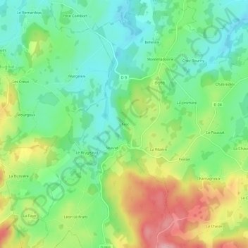
Name: Cheix topographic map, elevation, terrain.
Average elevation: 544 m
Minimum elevation: 486 m
Maximum elevation: 643 m
Other topographic maps
Click on a map to view its topography, its elevation and its terrain.
Les Peyrudes Hautes
France > Nouvelle-Aquitaine > Creuse > Champagnat
Les Peyrudes Hautes, Champagnat, Aubusson, Creuse, Nouvelle-Aquitaine, France métropolitaine, 23190, France
Average elevation: 514 m