
La Brisière topographic map
Interactive map
Click on the map to display elevation.
About this map
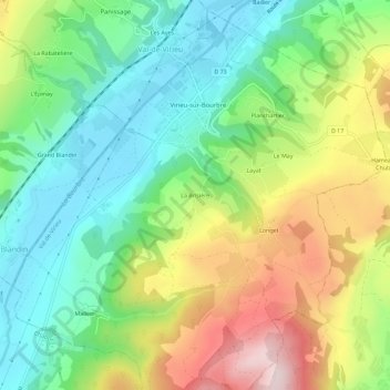
Name: La Brisière topographic map, elevation, terrain.
Average elevation: 530 m
Minimum elevation: 383 m
Maximum elevation: 774 m
Other topographic maps
Click on a map to view its topography, its elevation and its terrain.
Les Ayes
France > Auvergne-Rhône-Alpes > Isère > Val-de-Virieu > Les Ayes
Les Ayes, Panissage, Val-de-Virieu, La Tour-du-Pin, Isère, Auvergne-Rhône-Alpes, France métropolitaine, 38730, France
Average elevation: 495 m
Sarapin
France > Auvergne-Rhône-Alpes > Isère > Val-de-Virieu
Sarapin, Panissage, Val-de-Virieu, La Tour-du-Pin, Isère, Auvergne-Rhône-Alpes, France métropolitaine, 38730, France
Average elevation: 509 m
Virieu
France > Auvergne-Rhône-Alpes > Isère > Val-de-Virieu
Virieu, Val-de-Virieu, La Tour-du-Pin, Isère, Auvergne-Rhône-Alpes, France métropolitaine, 38730, France
Average elevation: 544 m
Longet
France > Auvergne-Rhône-Alpes > Isère > Val-de-Virieu
Longet, Virieu, Val-de-Virieu, La Tour-du-Pin, Isère, Auvergne-Rhône-Alpes, France métropolitaine, 38730, France
Average elevation: 563 m
Mallein
France > Auvergne-Rhône-Alpes > Isère > Val-de-Virieu
Mallein, Virieu, Val-de-Virieu, La Tour-du-Pin, Isère, Auvergne-Rhône-Alpes, France métropolitaine, 38730, France
Average elevation: 541 m
Panissage
France > Auvergne-Rhône-Alpes > Isère > Val-de-Virieu
Panissage, Val-de-Virieu, La Tour-du-Pin, Isère, Auvergne-Rhône-Alpes, France métropolitaine, 38730, France
Average elevation: 519 m