
Make a donation
Etterschlag topographic map
Click on the map to display elevation.
Make a donation
About this map
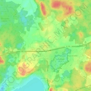
Name: Etterschlag topographic map, elevation, terrain.
Average elevation: 582 m
Minimum elevation: 556 m
Maximum elevation: 611 m
Make a donation
Other topographic maps
Click on a map to view its topography, its elevation and its terrain.
Starnberger See
Deutschland > Bayern > Landkreis Starnberg
Vor dem westlichen Ufer, auf Höhe von Feldafing, liegt eine kleine Insel, die Roseninsel.
Average elevation: 639 m
Berg
Deutschland > Bayern > Landkreis Starnberg > Berg
Es gibt die Gemarkungen Bachhausen, Berg, Höhenrain, Kempfenhausen und Wadlhauser Gräben.
Average elevation: 630 m
Starnberg
Deutschland > Bayern > Landkreis Starnberg
Die reizvolle Lage des Schlosses am Würmsee (1962 in Starnberger See umbenannt) führte schon ab 1490 zum Aufbau eines Schiffparks. Seinen Höhepunkt fand er mit dem Bau des Bucentaur, einem Prunkschiff, das Kurfürst Ferdinand Maria 1662 für seine Gemahlin Henriette Adelaide nach venezianischem Vorbild…
Average elevation: 631 m
Make a donation
Gilching
Deutschland > Bayern > Landkreis Starnberg
Einmal im Jahr fand das Gilchinger Volksfest auf dem Festplatz statt. Höhepunkt dabei war der traditionelle Einzug der Vereine in das Festzelt am Eröffnungstag.
Average elevation: 571 m
Andechs
Deutschland > Bayern > Landkreis Starnberg
Die Gemeinde liegt auf einem Höhenrücken zwischen dem Ammersee im Westen und dem Starnberger See im Osten. Der Rücken entstand durch Gletscherablagerungen zwischen den beiden Haupt-Gletscherzungen des Isar-Loisach-Gletschers, die für die beiden Zungenbeckenseen verantwortlich waren und weist auf seiner…
Average elevation: 621 m
Make a donation
Herrsching am Ammersee
Deutschland > Bayern > Landkreis Starnberg
Die geologische Formation des Fünfseenlandes entstand in der letzten Eiszeit, der sogenannten Würmeiszeit, die vor geschätzt 10.000 Jahren zu Ende ging. In Fließrichtung der Gletscher entstanden die hohen Seitenmoränen, etwa der Andechser Höhenrücken und die Untergrabungen für die späteren Seen. Der…
Average elevation: 595 m
Make a donation
Starnberger See
Deutschland > Bayern > Landkreis Starnberg > Starnberger See
Vor dem westlichen Ufer, auf Höhe von Feldafing, liegt eine kleine Insel, die Roseninsel.
Average elevation: 639 m
Inning am Ammersee
Deutschland > Bayern > Landkreis Starnberg
Im Jahr 2022 erzielte Inning am Ammersee Einnahmen aus der Gewerbesteuer in Höhe von 7,7 Millionen Euro. Mit einem Gewerbesteuerhebesatz von 340 % ist Inning eine der gewerbesteuerlich attraktivsten Gemeinden Deutschlands.
Average elevation: 561 m
Feldafing
Deutschland > Bayern > Landkreis Starnberg
Feldafing ist eine Gemeinde im oberbayerischen Landkreis Starnberg. Der Ort liegt auf einer Höhe um 650 m ü. NHN am Westufer des Starnberger Sees und bietet einen Rundblick über den See und einen Teil der Alpen.
Average elevation: 633 m
Make a donation
Weßlinger See
Deutschland > Bayern > Landkreis Starnberg > Neuhochstadt
Der Weßlinger See ist ein isolierter See. Das heißt, er besitzt keine natürlichen Zu- oder Abflüsse und wird ausschließlich durch unterirdische Quellen gespeist. Aus diesem Grund gibt es in ihm keinen natürlich gewachsenen Fischbestand. Fische, welche aus wirtschaftlichen Interessen immer wieder…
Average elevation: 597 m
Schloss Possenhofen
Deutschland > Bayern > Landkreis Starnberg > Possenhofen
Hörwarths Witwe verkaufte 1668 den Besitz für 30 000 Gulden an Kurfürst Ferdinand Maria. Schloss Possenhofen wurde fortan vom bayerischen Herrscherpaar und dessen Hofgesellschaft während Ausfahrten mit dem Prunkschiff Bucentaur und dessen Begleitflotte genutzt. Ferdinand Maria starb 1679. Dessen Sohn…
Average elevation: 614 m
Make a donation
Seefeld
Deutschland > Bayern > Landkreis Starnberg
Im Jahr 2022 erzielte Seefeld Einnahmen aus der Gewerbesteuer in Höhe von 11,15 Millionen Euro. Mit einem Gewerbesteuerhebesatz von 320 % zählt die Gemeinde zu den steuerlich attraktiven Standorten Deutschlands. Seefeld ist etwa steuerlich deutlich günstiger als die Landeshauptstadt München…
Average elevation: 601 m
Krailling
Deutschland > Bayern > Landkreis Starnberg
Im Jahr 2022 erzielte Krailling Einnahmen aus der Gewerbesteuer in Höhe von 4,36 Millionen Euro. Mit einem Gewerbesteuerhebesatz von 310 % zählt die Gemeinde zu den steuerlich attraktivsten Standorten Deutschlands. Krailling ist etwa steuerlich deutlich günstiger als die Landeshauptstadt München…
Average elevation: 564 m
Make a donation
Starnberg
Deutschland > Bayern > Landkreis Starnberg
Die reizvolle Lage des Schlosses am Würmsee (1962 in Starnberger See umbenannt) führte schon ab 1490 zum Aufbau eines Schiffparks. Seinen Höhepunkt fand er mit dem Bau des Bucentaur, einem Prunkschiff, das Kurfürst Ferdinand Maria 1662 für seine Gemahlin Henriette Adelaide nach venezianischem Vorbild…
Average elevation: 631 m
Gilching
Deutschland > Bayern > Landkreis Starnberg
Einmal im Jahr fand das Gilchinger Volksfest auf dem Festplatz statt. Höhepunkt dabei war der traditionelle Einzug der Vereine in das Festzelt am Eröffnungstag.
Average elevation: 571 m
Gilching
Deutschland > Bayern > Landkreis Starnberg
Einmal im Jahr fand das Gilchinger Volksfest auf dem Festplatz statt. Höhepunkt dabei war der traditionelle Einzug der Vereine in das Festzelt am Eröffnungstag.
Average elevation: 571 m
Make a donation