
Thank you for supporting this site ❤️
Make a donation
Make a donation
Westover Hills topographic map
Click on the map to display elevation.
Thank you for supporting this site ❤️
Make a donation
Make a donation
About this map
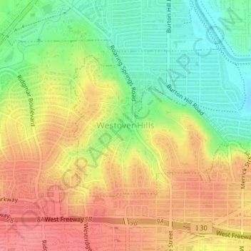
Name: Westover Hills topographic map, elevation, terrain.
Location: Westover Hills, Tarrant County, Texas, United States (32.73721 -97.42079 32.75242 -97.40042)
Average elevation: 201 m
Minimum elevation: 161 m
Maximum elevation: 236 m
Thank you for supporting this site ❤️
Make a donation
Make a donation
Other topographic maps
Click on a map to view its topography, its elevation and its terrain.
Thank you for supporting this site ❤️
Make a donation
Make a donation
Thank you for supporting this site ❤️
Make a donation
Make a donation
Will Rogers Memorial Center
United States > Texas > Tarrant County > Fort Worth
Average elevation: 181 m
Thank you for supporting this site ❤️
Make a donation
Make a donation
Thank you for supporting this site ❤️
Make a donation
Make a donation
Thank you for supporting this site ❤️
Make a donation
Make a donation