
Make a donation
Dieringhausen topographic map
Click on the map to display elevation.
Make a donation
About this map
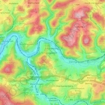
Name: Dieringhausen topographic map, elevation, terrain.
Average elevation: 244 m
Minimum elevation: 136 m
Maximum elevation: 377 m
Make a donation
Other topographic maps
Click on a map to view its topography, its elevation and its terrain.
Genkeltalsperre
Deutschland > Nordrhein-Westfalen > Oberbergischer Kreis > Gummersbach > Helberg
Der Staudamm der Genkeltalsperre besteht aus einer Steinschüttung ohne Vermörtelung. Auf der Wasserseite ist er mit einer doppelten Asphaltbetondecke wasserdicht abgedeckt. Auf der Luftseite wurde die Böschung mit Rasen- und Strauchgruppen landschaftsgerecht gestaltet. Die Höhe des Dammes beträgt 41 m…
Average elevation: 391 m
Bernberg
Deutschland > Nordrhein-Westfalen > Oberbergischer Kreis > Gummersbach
Die Haltestellen ‚Hahnenkroh‘, ‚Bernberg‘ und ‚Altenzentrum‘ werden über die Buslinie 303 (Gummersbach – Eckenhagen / Waldbröl), die Haltestellen ‚Hahnenkroh‘, ‚Großenbernberger Str.‘, ‚Südring Mitte‘, ‚Falkenhöhe‘ und ‚Bernberg‘ auch durch die Buslinie 364 (Rundverkehr Gummersbach – Bernberg) angeschlossen.
Average elevation: 284 m
Sonnenberg
Deutschland > Nordrhein-Westfalen > Oberbergischer Kreis > Gummersbach > Gummeroth
Average elevation: 336 m
Karlskamp
Deutschland > Nordrhein-Westfalen > Oberbergischer Kreis > Gummersbach
Average elevation: 300 m
Make a donation
Unnenberg
Deutschland > Nordrhein-Westfalen > Oberbergischer Kreis > Gummersbach
Average elevation: 368 m
Nöckelseßmar
Deutschland > Nordrhein-Westfalen > Oberbergischer Kreis > Gummersbach > Mühlenseßmar
Average elevation: 270 m
Lope
Deutschland > Nordrhein-Westfalen > Oberbergischer Kreis > Gummersbach
1546 wird der Ort erstmals urkundlich mit der Ortsbezeichnung „yn der Lope“ in der Türkensteuerliste erwähnt. Der ehemals eigenständige Ortsteil Lope gehört seit den 1950er Jahren zum nördlich gelegenen Ort Strombach. Die Ortsbezeichnung Lope wird jedoch sowohl in allen historischen wie auch in den…
Average elevation: 290 m
Halstenbach
Deutschland > Nordrhein-Westfalen > Oberbergischer Kreis > Gummersbach > Höfen
Average elevation: 245 m
Make a donation
Mühlenseßmar
Deutschland > Nordrhein-Westfalen > Oberbergischer Kreis > Gummersbach
Average elevation: 281 m
Berstig
Deutschland > Nordrhein-Westfalen > Oberbergischer Kreis > Gummersbach
Average elevation: 261 m
Niederseßmar
Deutschland > Nordrhein-Westfalen > Oberbergischer Kreis > Gummersbach
Niederseßmar erstreckt sich vom Zusammenfluss des Seßmarbachs und der Agger ausgehend entlang beider Flusstäler sowie an den Hängen umliegender Höhenzüge, vornehmlich der Karhelle (334 m ü. NN).
Average elevation: 262 m
Hülsenbusch
Deutschland > Nordrhein-Westfalen > Oberbergischer Kreis > Gummersbach
Average elevation: 311 m
Make a donation
Kalteneich
Deutschland > Nordrhein-Westfalen > Oberbergischer Kreis > Gummersbach > Dümmlinghausen
Average elevation: 279 m
Vollmerhausen
Deutschland > Nordrhein-Westfalen > Oberbergischer Kreis > Gummersbach
Average elevation: 258 m
Make a donation
Aggertalsperre
Deutschland > Nordrhein-Westfalen > Oberbergischer Kreis > Gummersbach > Bredenbruch
Average elevation: 331 m
Ohmig
Deutschland > Nordrhein-Westfalen > Oberbergischer Kreis > Gummersbach > Dieringhausen
Average elevation: 228 m
Flaberg
Deutschland > Nordrhein-Westfalen > Oberbergischer Kreis > Gummersbach
Average elevation: 261 m
Berghausen
Deutschland > Nordrhein-Westfalen > Oberbergischer Kreis > Gummersbach
Der Ort liegt auf einem Höhenrücken zwischen den hier parallel verlaufenden Flusstälern von Leppe und Gelpe. Über die Landesstraßen L 323 und L 307 erreicht man vom Stadtzentrum aus die an der L 98 liegende Ortschaft nach gut 9 Kilometern.
Average elevation: 276 m
Make a donation
Frömmersbach
Deutschland > Nordrhein-Westfalen > Oberbergischer Kreis > Gummersbach > Frömmersbach
Average elevation: 332 m
Derschlag
Deutschland > Nordrhein-Westfalen > Oberbergischer Kreis > Gummersbach > Derschlag
Average elevation: 278 m
Rebbelroth
Deutschland > Nordrhein-Westfalen > Oberbergischer Kreis > Gummersbach
Average elevation: 276 m
Hunstig
Deutschland > Nordrhein-Westfalen > Oberbergischer Kreis > Gummersbach > Dieringhausen
Average elevation: 229 m
Make a donation
Brunohl
Deutschland > Nordrhein-Westfalen > Oberbergischer Kreis > Gummersbach > Erbland
Average elevation: 243 m
Windhagen
Deutschland > Nordrhein-Westfalen > Oberbergischer Kreis > Gummersbach
Average elevation: 331 m
Wasserfuhr
Deutschland > Nordrhein-Westfalen > Oberbergischer Kreis > Gummersbach
Average elevation: 318 m
Nordhelle
Deutschland > Nordrhein-Westfalen > Oberbergischer Kreis > Gummersbach
Average elevation: 292 m
Make a donation
Derschlag
Deutschland > Nordrhein-Westfalen > Oberbergischer Kreis > Gummersbach
Gesicherte Nachweise über die Besiedlung des Ortes Derschlag gaben die beiden befestigten Burghäuser, die im Ort standen. Konkrete Hinweise bezüglich der Gründung dieser Anlagen liegen allerdings nicht vor. Da steinerne Befestigungsanlagen in der Regel erst im Hochmittelalter erbaut wurden, lässt sich aus…
Average elevation: 278 m
Helberg
Deutschland > Nordrhein-Westfalen > Oberbergischer Kreis > Gummersbach
Average elevation: 371 m
Lantenbach
Deutschland > Nordrhein-Westfalen > Oberbergischer Kreis > Gummersbach
Average elevation: 353 m
Ahlefeld
Deutschland > Nordrhein-Westfalen > Oberbergischer Kreis > Gummersbach
Average elevation: 259 m
Make a donation