
Athas topographic map
Interactive map
Click on the map to display elevation.
About this map
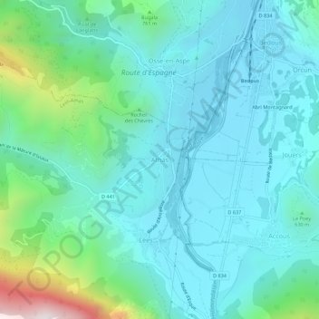
Name: Athas topographic map, elevation, terrain.
Average elevation: 609 m
Minimum elevation: 400 m
Maximum elevation: 1,538 m
Other topographic maps
Click on a map to view its topography, its elevation and its terrain.
Les Orgues de Camplong
France > Nouvelle-Aquitaine > Pyrénées-Atlantiques > Lées-Athas
Les Orgues de Camplong, Lées-Athas, Oloron-Sainte-Marie, Pyrénées-Atlantiques, Nouvelle-Aquitaine, France métropolitaine, 64490, France
Average elevation: 1,665 m
Lées
France > Nouvelle-Aquitaine > Pyrénées-Atlantiques > Lées-Athas
Lées, Lées-Athas, Oloron-Sainte-Marie, Pyrénées-Atlantiques, Nouvelle-Aquitaine, France métropolitaine, 64490, France
Average elevation: 731 m