
Saint-Géry topographic map
Interactive map
Click on the map to display elevation.
About this map
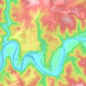
Name: Saint-Géry topographic map, elevation, terrain.
Average elevation: 239 m
Minimum elevation: 119 m
Maximum elevation: 368 m
Other topographic maps
Click on a map to view its topography, its elevation and its terrain.
Pech Picou
France > Occitanie > Lot > Saint-Géry-Vers
Pech Picou, Vers, Saint-Géry-Vers, Cahors, Lot, Occitanie, France métropolitaine, 46090, France
Average elevation: 226 m
Vers
France > Occitanie > Lot > Saint-Géry-Vers
Vers, Saint-Géry-Vers, Cahors, Lot, Occitanie, France métropolitaine, 46090, France
Average elevation: 240 m