
Merseyside topographic map
Interactive map
Click on the map to display elevation.
About this map
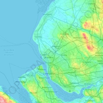
Name: Merseyside topographic map, elevation, terrain.
Average elevation: 23 m
Minimum elevation: -1 m
Maximum elevation: 243 m
Other topographic maps
Click on a map to view its topography, its elevation and its terrain.
Littler
Vereinigtes Königreich > England > Cheshire West and Chester > Winsford
Littler, Winsford, Cheshire West and Chester, England, CW7 2XJ, Vereinigtes Königreich
Average elevation: 53 m
Dunham on the Hill
Vereinigtes Königreich > England > Cheshire West and Chester
Dunham on the Hill, Cheshire West and Chester, England, WA6 0LX, Vereinigtes Königreich
Average elevation: 20 m
Grandsires Green
Vereinigtes Königreich > England > Cheshire West and Chester > Antrobus
Grandsires Green, Antrobus, Cheshire West and Chester, England, CW9 6NJ, Vereinigtes Königreich
Average elevation: 58 m