
Thank you for supporting this site ❤️
Make a donation
Make a donation
Witzenhausen topographic map
Click on the map to display elevation.
Thank you for supporting this site ❤️
Make a donation
Make a donation
About this map
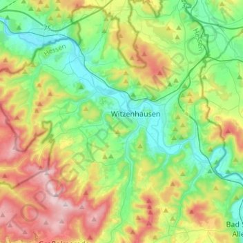
Name: Witzenhausen topographic map, elevation, terrain.
Location: Witzenhausen, Werra-Meißner-Kreis, Hesse, Germany (51.26416 9.70186 51.41080 9.94810)
Average elevation: 297 m
Minimum elevation: 124 m
Maximum elevation: 627 m
Thank you for supporting this site ❤️
Make a donation
Make a donation
Other topographic maps
Click on a map to view its topography, its elevation and its terrain.