
Thank you for supporting this site ❤️
Make a donation
Make a donation
Plettenberg topographic map
Click on the map to display elevation.
Thank you for supporting this site ❤️
Make a donation
Make a donation
Plettenberg
Plettenberg is located to the west of the Sauerland hills. The highest elevation of the town area is in the Ebbegebirge with 663 m above sea level, the lowest elevation with 194 m near Teindeln. The town is spread out between the four valleys of the rivers Lenne, Else, Oester [de] and Grüne.
Thank you for supporting this site ❤️
Make a donation
Make a donation
About this map
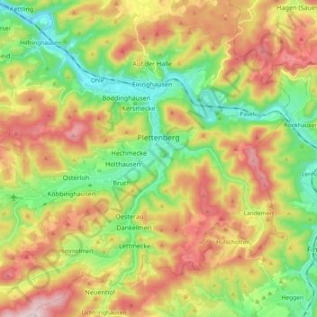
Name: Plettenberg topographic map, elevation, terrain.
Average elevation: 378 m
Minimum elevation: 186 m
Maximum elevation: 630 m
Thank you for supporting this site ❤️
Make a donation
Make a donation