
Make a donation
Póvoa de Varzim topographic map
Click on the map to display elevation.
Make a donation
Póvoa de Varzim
There are no full-days below freezing, yet temperatures below 0 °C (32.0 °F) can occur at the height of winter during the night and early morning. The city possesses a microclimate and is considered the region least subject to frosts in all northern Portugal. Cold waves are absent and snowfall is firmly uncommon, the last occurred in January 1986. More recently, snowfall occurred inland. This is due to the winter maritime winds that normally blow from the south and southwest. Most of the rain is concentrated in the winter months, due to the Azores High which influences the subsidence of the air resulting in dry air during the summer. Topography and distance from the sea influence precipitation even at short distances. The urban core receives over 900 millimetres (35 in), the outskirts can get up to 1,200 millimetres (47 in) of rain per year, while the city's countryside can get up to 1,500 millimetres (59 in).
Make a donation
About this map
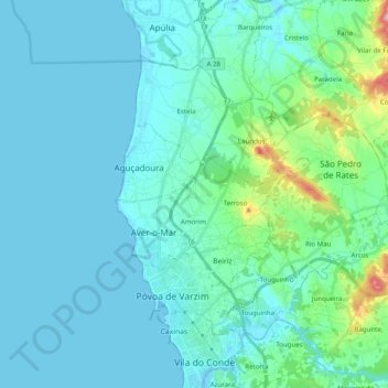
Name: Póvoa de Varzim topographic map, elevation, terrain.
Location: Póvoa de Varzim, Porto, Portugal (41.36457 -8.78906 41.47197 -8.59065)
Average elevation: 25 m
Minimum elevation: -2 m
Maximum elevation: 188 m
Make a donation
Other topographic maps
Click on a map to view its topography, its elevation and its terrain.
Make a donation
Make a donation
Make a donation
Santa Marinha do Zêzere
Portugal > Porto > Santa Marinha do Zêzere > Santa Marinha do Zêzere
Average elevation: 425 m
Make a donation
Make a donation
São Tomé de Covelas
Portugal > Porto > Santa Cruz do Douro e São Tomé de Covelas
Average elevation: 356 m