
Thank you for supporting this site ❤️
Make a donation
Make a donation
Pitigliano topographic map
Click on the map to display elevation.
Thank you for supporting this site ❤️
Make a donation
Make a donation
Pitigliano
The municipality area of Pitigliano, while presenting different local situations on the basis of 'topography is characterized by rather low winter temperatures, which can occur during prolonged periods, despite the daily maximum values are often pleasing. On the contrary, in summer the heat can be very intense, though usually accompanied by low relative humidity.
Thank you for supporting this site ❤️
Make a donation
Make a donation
About this map
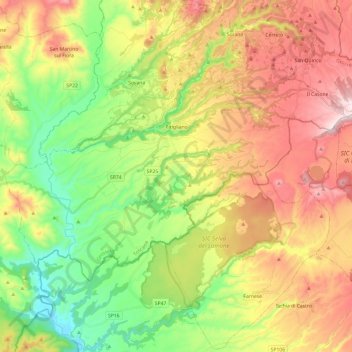
Name: Pitigliano topographic map, elevation, terrain.
Average elevation: 331 m
Minimum elevation: 98 m
Maximum elevation: 620 m
Thank you for supporting this site ❤️
Make a donation
Make a donation
Other topographic maps
Click on a map to view its topography, its elevation and its terrain.
Thank you for supporting this site ❤️
Make a donation
Make a donation
Thank you for supporting this site ❤️
Make a donation
Make a donation
Thank you for supporting this site ❤️
Make a donation
Make a donation
Thank you for supporting this site ❤️
Make a donation
Make a donation
Thank you for supporting this site ❤️
Make a donation
Make a donation
Thank you for supporting this site ❤️
Make a donation
Make a donation