Geolocate

Lake Erie topographic map

Interactive map

Click on the map to display elevation.

Lake Erie

Situated below Lake Huron, Erie's primary inlet is the Detroit River. The main natural outflow from the lake is via the Niagara River, which provides hydroelectric power to Canada and the U.S. as it spins huge turbines near Niagara Falls at Lewiston, New York and Queenston, Ontario. Some outflow occurs via the Welland Canal, part of the Saint Lawrence Seaway, which diverts water for ship passages from Port Colborne, Ontario on Lake Erie, to St. Catharines on Lake Ontario, an elevation difference of 326 ft (99 m). Lake Erie's environmental health has been an ongoing concern for decades, with issues such as overfishing, pollution, algae blooms, and eutrophication generating headlines.

Wikipedia (CC-BY-SA 3.0)

About this map

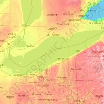
Name: Lake Erie topographic map, elevation, terrain.

Location: Lake Erie, Ohio, United States (41.38068 -83.47871 42.90584 -78.84648)

Average elevation: 267 m

Minimum elevation: 73 m

Maximum elevation: 769 m

Other topographic maps

Click on a map to view its topography, its elevation and its terrain.

Rose Lake

United States > Ohio > Hocking County

Average elevation: 295 m

Beaver Island

United States > Ohio > Mahoning County > Boardman

Average elevation: 328 m

Wolfcale

United States > Ohio > Van Wert County

Average elevation: 245 m

Burr Oak State Park

United States > Ohio > Morgan County

Average elevation: 251 m

Campbell Hill

United States > Ohio > Logan County > Bellefontaine

Campbell Hill is, at 1,549.09 feet (472.16 m), the highest point in elevation in the U.S. state of Ohio. Campbell Hill is located within the city of Bellefontaine, 2 miles (3.2 km) northeast of downtown.

Average elevation: 444 m

Sagamore Hills

United States > Ohio > Summit County

Average elevation: 264 m

Towner's Woods

United States > Ohio > Portage County

Average elevation: 329 m

Buena Vista

United States > Ohio > Scioto County

Average elevation: 220 m

Hammondsville

United States > Ohio > Jefferson County

Average elevation: 293 m

Spring Mountain

United States > Ohio > Coshocton County

Average elevation: 326 m

Moss Run

United States > Ohio > Washington County

Average elevation: 250 m

Fort McKinley

United States > Ohio > Montgomery County > Dayton

Average elevation: 273 m

Claylick

United States > Ohio > Licking County

Average elevation: 258 m

Homer

United States > Ohio > Licking County

Average elevation: 311 m

Brukner Park

United States > Ohio > Miami County > Troy

Average elevation: 256 m

Chaska Beach

United States > Ohio > Erie County > Huron

Average elevation: 177 m

Pharisburg

United States > Ohio > Union County

Average elevation: 292 m

Mount Lookout

United States > Ohio > Auglaize County

Average elevation: 316 m

Crescent

United States > Ohio > Belmont County

Average elevation: 314 m

North Baltimore

United States > Ohio > Wood County

Average elevation: 219 m

Avon Center

United States > Ohio > Lorain County > Avon

Average elevation: 201 m

Brookville

United States > Ohio > Athens County

Average elevation: 236 m

Tedrow

United States > Ohio > Fulton County > Tedrow

Average elevation: 232 m

Alfred

United States > Ohio > Meigs County

Average elevation: 228 m

Cleveland

United States > Ohio > Cuyahoga County > Cleveland

The land rises quickly from the lake shore elevation of 569 feet. Public Square, less than one mile (1.6 km) inland, sits at an elevation of 650 feet (198 m), and Hopkins Airport, 5 miles (8 km) inland from the lake, is at an elevation of 791 feet (241 m).

Average elevation: 221 m

The Highlands

United States > Ohio > Muskingum County

Average elevation: 280 m

Oak Ridge

United States > Ohio > Montgomery County > Centerville

Average elevation: 298 m

Dillon Lake

United States > Ohio > Muskingum County

Average elevation: 258 m

Mayfield

United States > Ohio > Butler County > Middletown

Average elevation: 212 m

Russell

United States > Ohio > Highland County

Average elevation: 321 m

Hickory Grove

United States > Ohio > Ottawa County

Average elevation: 174 m

Vulcan

United States > Ohio > Lucas County > Toledo

Average elevation: 190 m

East Cambridge

United States > Ohio > Guernsey County > Cambridge

Average elevation: 261 m

Camp Crowell Dam

United States > Ohio > Summit County

Average elevation: 355 m

Summit Park

United States > Ohio > Hamilton County > Blue Ash

Average elevation: 254 m

Newbury

United States > Ohio > Geauga County

Average elevation: 367 m

Welshfield

United States > Ohio > Geauga County > Troy Township

Average elevation: 352 m

Huntcrest Acres

United States > Ohio > Hamilton County

Average elevation: 252 m

Herbert Corners

United States > Ohio > Mahoning County

Average elevation: 344 m

Windsor

United States > Ohio > Ashtabula County

Average elevation: 266 m

Lemert

United States > Ohio > Crawford County

Average elevation: 292 m

Eldean

United States > Ohio > Miami County

Average elevation: 266 m

Lake Cable

United States > Ohio > Stark County

Average elevation: 340 m

Colton

United States > Ohio > Henry County

Average elevation: 206 m

Rose Lake Dam

United States > Ohio > Hocking County

Average elevation: 297 m

Willow Glen

United States > Ohio > Tuscarawas County > Dover

Average elevation: 281 m

Hill Grove

United States > Ohio > Darke County

Average elevation: 327 m

Fox Acres

United States > Ohio > Hamilton County > Cincinnati

Average elevation: 261 m

Williamsfield

United States > Ohio > Ashtabula County

Average elevation: 345 m

Ohmer Park

United States > Ohio > Montgomery County > Dayton

Average elevation: 270 m

Post Town

United States > Ohio > Montgomery County > Trotwood

Average elevation: 272 m

Bridgetown

United States > Ohio > Hamilton County > Bridgetown

Average elevation: 263 m

Columbus Feeder

United States > Ohio > Franklin County > Columbus

Average elevation: 213 m

Columbus

United States > Ohio > Franklin County > Columbus

The confluence of the Scioto and Olentangy rivers is just north-west of Downtown Columbus. Several smaller tributaries course through the Columbus metropolitan area, including Alum Creek, Big Walnut Creek, and Darby Creek. Columbus is considered to have relatively flat topography thanks to a large glacier that…

Average elevation: 255 m

Creola

United States > Ohio > Vinton County

Average elevation: 256 m

Amelia

United States > Ohio > Clermont County

Average elevation: 265 m

Little York

United States > Ohio > Montgomery County

Average elevation: 269 m

Huntsburg

United States > Ohio > Geauga County

Average elevation: 361 m

Hemlock Falls

United States > Ohio > Richland County

Average elevation: 368 m

Cincinnati

United States > Ohio > Hamilton County

Cincinnati has several standard modes of transportation including sidewalks, roads, public transit, bicycle paths and airports. The city's hills preclude the regular street grid common to many cities built up in the 19th century, and outside of the downtown basin, regular street grids are rare except for in…

Average elevation: 225 m

Lewis Center

United States > Ohio > Delaware County

Average elevation: 286 m

Valley City

United States > Ohio > Medina County

Average elevation: 262 m

Westgate Park

United States > Ohio > Franklin County > Columbus

Average elevation: 253 m

Oakgrove

United States > Ohio > Clark County

Average elevation: 300 m

New California

United States > Ohio > Union County

Average elevation: 299 m

Appleton

United States > Ohio > Licking County

Average elevation: 350 m

Pfeiffer

United States > Ohio > Hardin County

Average elevation: 294 m

Curtice

United States > Ohio > Ottawa County

Average elevation: 182 m

Bevis

United States > Ohio > Hamilton County

Average elevation: 265 m

Yelverton

United States > Ohio > Hardin County

Average elevation: 329 m

Moorefield

United States > Ohio > Harrison County

Average elevation: 319 m

New Rumley

United States > Ohio > Harrison County

Average elevation: 349 m

Lake Buckhorn

United States > Ohio > Holmes County > Clark

Average elevation: 300 m

Jump

United States > Ohio > Hardin County

Average elevation: 303 m

Miamitown

United States > Ohio > Hamilton County

Average elevation: 192 m