
Thank you for supporting this site ❤️
Make a donation
Make a donation
Frammeringermoos topographic map
Click on the map to display elevation.
Thank you for supporting this site ❤️
Make a donation
Make a donation
About this map
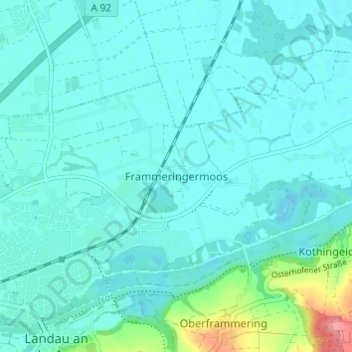
Name: Frammeringermoos topographic map, elevation, terrain.
Average elevation: 343 m
Minimum elevation: 328 m
Maximum elevation: 432 m
Thank you for supporting this site ❤️
Make a donation
Make a donation
Other topographic maps
Click on a map to view its topography, its elevation and its terrain.
94405
Deutschland > Bayern > Landkreis Dingolfing-Landau > Landau an der Isar > Fichtheim
Average elevation: 387 m