
Faux-la-Montagne topographic map
Interactive map
Click on the map to display elevation.
About this map
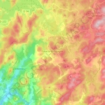
Name: Faux-la-Montagne topographic map, elevation, terrain.
Average elevation: 702 m
Minimum elevation: 515 m
Maximum elevation: 874 m
Other topographic maps
Click on a map to view its topography, its elevation and its terrain.
Pallier
Francia > Nuova Aquitania > Creuse > Saint-Médard-la-Rochette > Pallier
Pallier, Saint-Médard-la-Rochette, Aubusson, Creuse, Nuova Aquitania, Francia metropolitana, 23200, Francia
Average elevation: 503 m