
Country Club Park topographic map
Interactive map
Click on the map to display elevation.
About this map
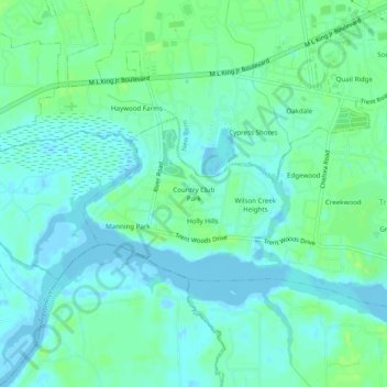
Name: Country Club Park topographic map, elevation, terrain.
Average elevation: 5 m
Minimum elevation: -5 m
Maximum elevation: 12 m
Other topographic maps
Click on a map to view its topography, its elevation and its terrain.
Trent Shores
United States > North Carolina > Craven County > Trent Woods
Trent Shores, Trent Woods, Craven County, North Carolina, 28562, United States
Average elevation: 4 m
Creekwood
United States > North Carolina > Craven County > Trent Woods
Creekwood, Trent Woods, Craven County, North Carolina, 28562, United States
Average elevation: 5 m